Magnetometer, line locating, borehole logging, and noise testing methods are a suite of miscellaneous geophysical applications allows engineers and professionals methods to address very specific problems. Geometrics G858 magnetometer and G856 magnetometer are top of list in magnetometers. The G858 magnetometer integrates GPS positioning when available. Radio Detection RD8200 from SPX, Pipe Horn’s 800 locator, 3M’s Dynatel Locating system, and Aquatronics A-6 Tracer offer superior line-locating capabilities for projects of all sizes. For noise testing, Casella provides reliable solutions and Mount Sopris offers state-of-the-art borehole logging systems. Utilizing these advanced products ensures desirable results while reducing potential delays caused by inaccurate data. Furthermore, these geophysical applications can save time as well as money.
Exploring Geometrics G858 and G856 Magnetometers a Market Leader
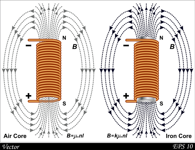
The Geometrics G-858 MagMapper Magnetometer and G856 Magnetometer are the market leader in providing reliable detection of underground ferrous objects such as drums, underground storage tanks, wells, pipelines, and other ferrous objects. These models feature a highly versatile design, allowing for easy integration of GPS positioning when available. The magnetometers use advanced technology to detect even the smallest variations in the earth’s magnetic field, which is essential. Additionally, they are capable of operating in various levels of magnetic field strength. This makes them suitable for a variety of environments. Furthermore, they are designed to be lightweight and compact while still boasting an impressive range and sensitivity. Geometrics’ magnetometers are known for their reliable performance and user-friendly design. It’s no wonder why they have become such a go-to for professionals and engineers alike.
Overview of Geometrics G-858 MagMapper Magnetometer
The G-858 MagMapper Magnetometer is a state-of-the art device for geophysical and environmental surveys. It offers unparalleled sensitivity and fast sampling speeds, allowing the operator to quickly survey an area in real time. With its easy-to-use graphical interface, it has never been easier to design a survey grid. The G-858 accepts NMEA strings from external RTK GPS receivers. Additionally, it features two different modes of data acquisition – continuous and discrete station recording. You can tailor the instrument to your survey needs. For even greater sensitivity and accuracy, a second sensor can be added. This allows for wider search zones or magnetic field gradients to be measured. Finally, its internal firmware has been optimized for UXO, archaeological, environmental, utility and mineral exploration applications alike. When it comes to a magnetometer that provides speed, accuracy, and versatility-the G-858 MagMapper is the clear go-to choice.
Overview of Geometrics G-856 Magnetometer
The G-856AX Magnetometer is an advanced, state-of-the-art geophysical instrument for magnetic field measurements. It is designed to be highly portable and offers a variety of configurations. It is suited for different applications, from hand-carried measurements to gradiometer readings or base station surveys. The instrument features push button operation and a built in digital memory. The memory stores over 5000 single sensor measurements or 2500 gradiometer readings. This eliminates the need for manual data collection in the field, allowing for quick and accurate data analysis.
The G-856AX can be used with specialized software programs such as MagMap2000 and MagPick. This software allows users to quickly process their survey data and interpret it more effectively. The G-856AX also offers superior accuracy when compared to other magnetometers on the market. It provides reliable results in even the most challenging conditions. In addition, the instrument has a robust design structure with overvoltage protection circuits. This ensures its longevity even in adverse environments. With these features, the G-856AX Magnetometer is an excellent choice for any magnetic field surveying task.
Benefits of Using state-of-the-art Line Locating Equipment
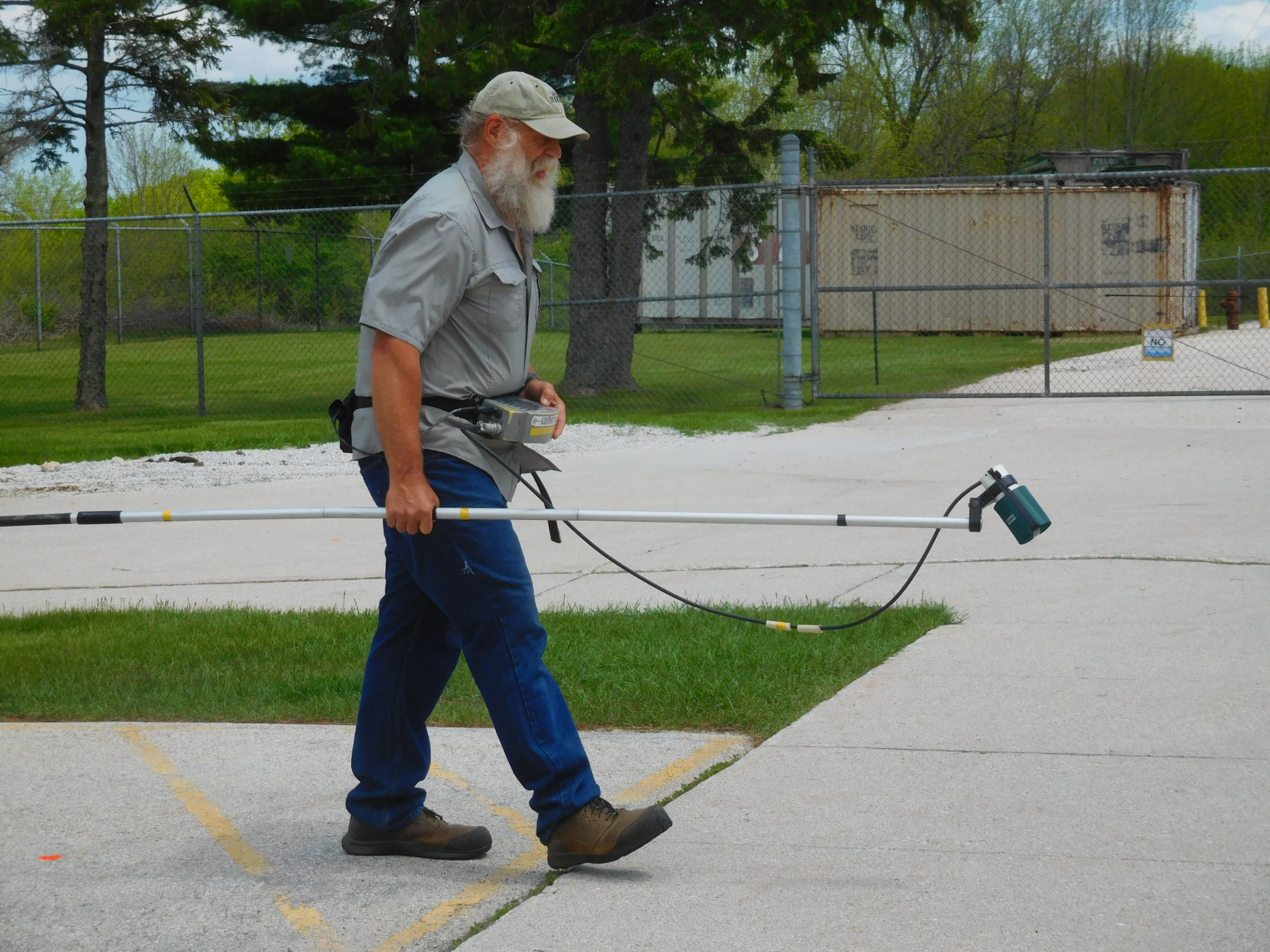
Utility line locating is a process and involves many methods designed to locate underground electrical, water, communication, and sewer lines. One of the most common methods used for utility line locating is direct connect. This method uses an electronic receiver to detect distinct signals coming from a transmitter attached to the line itself. Another method is induction, which is based on the principles of electromagnetic induction. A transmitter coil is placed close to or an induction coupler is clamped around a suspected line. The transmitter is configured to induce an electrical current onto the line being traced. The induced current produces a signal that is detected at the surface. GPS technology can also be used to record the location of a traced line.
Directional Peak utilizes a least one pair of directional antennas to better locate a line. Null methods search for locations where the signal along a line is zero or minimal strength. The passive 60Hz technique takes advantage of electromagnetic fields created by active electrical power lines. All these technologies have become increasingly sophisticated over time. Subsequently, the results are better than ever before. Especially, when it comes to tracing underground utilities in very difficult or densely populated areas.
The use of state-of-the-art line locating equipment
offers numerous advantages to engineers, professionals and projects of all sizes. By implementing the latest products from SPX, Pipe Horn, 3M, and Aquatronics, users can achieve a higher level of accuracy when it comes to locating lines. The accuracy they offer is much better than simpler methods like using visual cues or GPS coordinates. With these advanced systems, engineers are able to identify locations of underground utilities. With good site conditions, they measure depths and distances with greater accuracy. As a bonus, some of these systems are also capable of identifying plastic and non metallic pipes. A feature that simpler methods such as x-ray scanning or conventional electromagnetic tracing do not have. By implementing state-of-the-art line locating equipment, projects become more efficient and cost-effective. This reduces the need for additional labor or resources to locate pipelines.
Overview of SPX RD8200
The RD8200 range of locators and transmitters use an ergonomic handle design with advanced vibration alerts that make it easy to work in challenging conditions. With the alert system, operators are able to focus on the job at hand without distraction. The transflective low power LCD screen technology uses ambient light to improve readability under direct sun and extend battery life. Radiodetection’s TruDepth feature displays precise depth and current measurements when the locator is correctly oriented above the target, giving high confidence that the correct line is being traced. Additionally, it has a waterproof speaker housing tuned for optimum resonance for either high or low frequency tones, meaning operators can still receive audio feedback even in noisy environments. As such, this locator offers superior performance no matter what the environment may be.
Overview of Pipe Horn
The Pipehorn Series 800-HL is a powerful, cutting-edge tool used by professional locators to locate and trace pipes, cables, tracer wires, fiber optics, and other buried or concealed conductors. This dual-frequency tool allows for both low-frequency conductive locating and high-frequency inductive or conductive locating. It is designed with precision engineering to ensure many years of satisfactory service with reasonable care. The 800-HL is extremely easy to operate and understand.
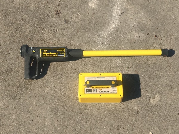
Despite its advanced technology, careful reading of the manual is recommended for optimal results. It can be used on a wide variety of surfaces such as wood, asphalt, concrete, soil, and rock . The transmitter is simple to use and can transmit signals through non-conductive pipes using metal sewer snakes or fish tapes. The 800-HL offers great accuracy and reliability even in challenging locations and conditions. Thanks to its strong signal transmission capabilities, it can quickly detect even the smallest changes in the orientation or depth of a target so that operators can trace its location.
Overview of 3M™ Dynatel™ Locator 2250M/2273M Series
The 3M™ Dynatel™ Locator 2250M/2273M Series is a powerful cable and pipe locator system that is used to identify the path and estimated depth of buried cables, pipes, and other hidden objects. This model has four active trace frequencies that allow it to accurately compensate for varying field conditions. Its receiver incorporates passive power and auxiliary frequencies, so users have more control over their searches. The device also features a vivid graphic display for easy identification of targeted cables from other objects present in the area. The locator also boasts a multi-antenna design which allows users to select from three locating modes- Directional Peak, Multi-Directional, Null, as well as single antenna special peak mode for deep depths. For improved left/right guidance and accurate locates in challenging conditions, directional mode utilizes an all-peak antenna design.
This powerful device is made with rugged construction which means it can survive tough job site conditions while providing reliable performance to ensure maximum safety throughout usage. The 3M™ Dynatel™ Locator 2250M/2273M Series can locate, write, and read information into the 3M™ iD Electronic Marker System. On top of this, the convenient design ensures easy transportation to help professionals move around quickly onsite or switch between jobs with ease. With all these advanced technologies combined, 3M™ Dynatel™ Locator 2250M/2273M Series offers one of the most reliable solutions available on the market today for locating buried cables in any situation imaginable!
Overview of Aquatronics A-6 Tracer
The Aquatronics A-6 Tracer is an advanced, self-contained system designed to detect sensitive pipes and cables. It offers three distinct methods of tracing: conductive tracing, inductive tracing, and on-handle searching. The conductive tracing system utilizes a transmitter with impedance-matching capabilities to energize the metal pipe or line for electromagnetic pickup. Variable power transmitters are available for crowded line locations and the system has burnout protection. The inductive tracing capability offers the largest antennas on the market to penetrate more deeply for pipe or cable detection. On-handle searching operates as a unequalled commercial metal detector that locates pipes, cables, conduits, man hole covers, storm drains, valves, or other buried metal.
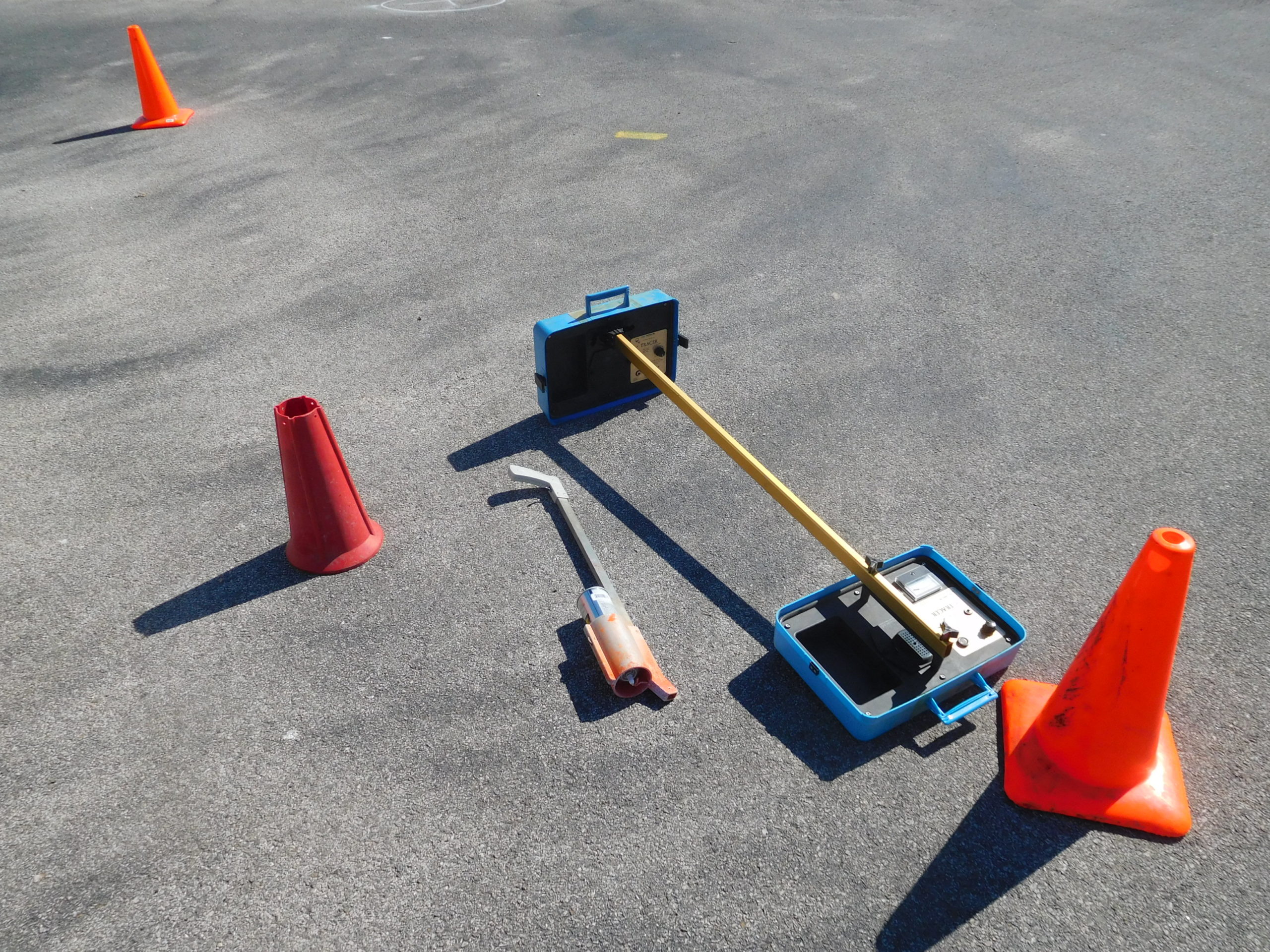
To maximize utility and portability, the entire system folds into one easy-to-carry case complete with a receiver and transmitter. Additionally, nonmetallic pipes can be traced using either the Sewer Snooper or Mini-Snooper accessories within the A-6 Tracer package. Inductive Couplers are also available to allow further flexibility in searches over broader ranges of both distance and complexity. With its powerful combination of features and convenience, the Aquatronics A-6 Tracer is an ideal choice when undertaking any type of pipe or cable search requiring exceptional sensitivity and accuracy.
Find Pages On EngineeringGeophysics.com
Noise Testing Solutions from Casella
Casella provides a comprehensive selection of noise testing solutions that can accurately capture sound levels in various environments. These instruments are designed to meet the most stringent noise testing requirements and can be used for both indoor and outdoor applications. The instrumentation provided by Casella includes highly accurate sound measuring devices that can be used for both short-term and long-term monitoring needs. These instruments feature a display with real-time post processing analysis. In addition, users can track changes in sound levels over time. These noise testing solutions are user-friendly, providing intuitive interfaces for easy setup and operation. Casella’s noise testing solutions are also cost-effective when compared to other instruments of similar quality.
A summary of Mount Sopris’s borehole logging systems
Mount Sopris’s borehole logging systems are designed to provide accurate information about the composition and characteristics of subsurface strata. The systems use advanced instrumentation, software, and analysis tools to accurately measure the physical properties of soil, rock, and other geological formations. Mount Sopris’s innovative technology can be used for both exploration and environmental assessment applications.
More about borehole logging
Borehole logging is an important and wide-ranging tool for the geoscience industry, providing reliable insights into the physical properties of cased and uncased boreholes. Borehole logging probes or sondes measure a variety of properties, including natural gamma ray, electrical, acoustic, stimulated radioactive responses, electromagnetic, nuclear magnetic resonance, pressure, and more. Note that borehole geophones and seismic source are found on the page about near surface seismics for engineers. These measurements can help to assess geological structure, fluid flow, and determine borehole integrity with great accuracy.
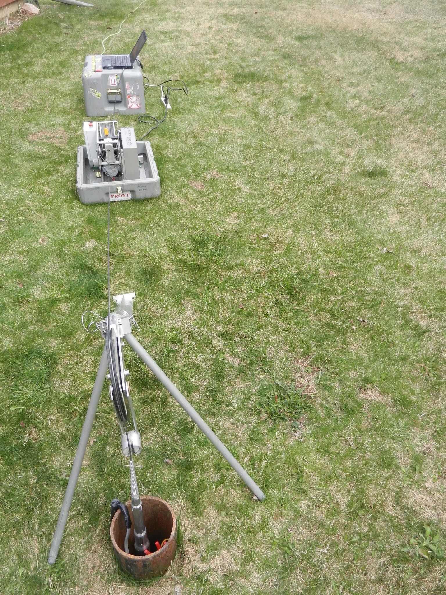
This technique has been further enhanced over time as advances in technology have given new life to old methods. For example, modern borehole logging systems now employ sophisticated computerized equipment that enables multiple parameters to be measured simultaneously. This provides more comprehensive data than was previously possible with traditional measurement technologies. Additionally, the integration of digital imaging systems (optical televiewer and acoustic televiewer) has enabled users to gain greater insight into the subsurface environment by creating detailed images from down-hole logs that may be used for in-depth analysis.
Another important feature of modern borehole logging systems is their ability to operate continuously in hostile environments such as high temperatures or submerged locations. This means operators can now collect data in locations that were previously inaccessible due to safety or technical reasons. Furthermore, continuous data acquisition is often much faster than techniques like core sampling or cuttings logging. Overall, borehole logging is an essential tool for geoscience professionals who need accurate and reliable insights into the subsurface environment. By combining traditional techniques with modern technology, logs can be acquired quickly and efficiently while still maintaining extremely high standards of precision and accuracy.
Summary of Magnetometer, Line Locating, Borehole Logging, and Noise Testing Methods
In conclusion, we can see that technology is changing the way we identify, measure, and analyze geological formations. With state-of-the-art equipment such as Geometrics G858 magnetometer and G856 Magnetometer; SPX’s RD8200 line and cable locator, Pipe Horn’s 800-HL locator, and Aquatronics A-6, and 3M’s Dynatel Locating system; noise testing solutions from Casella; as well as Mount Sopris’s borehole logging systems a market leaders in this industry – all of these tools provide accurate information about concerns below ground.
This technology provides the ability to more effectively locate buried ferrous metal, trace buried cables and pipes, monitor noise levels, and detail conditions at depth using sophisticated borehole tools. By incorporating cutting-edge instrumentation, software, and analysis tools into these systems, companies are better able to comprehend their environment – empowering them to make more informed decisions. Plus, the ever-evolving borehole technology has enhanced precision when examining geological structures; making it much easier for professionals to appraise geologic, hydrogeologic, environmental, or engineering issues.