GPR or ground penetrating radar is a type of equipment that engineers can use to locate underground objects and map conditions at depth. This technology has a wide range of applications, from locating buried utilities to mapping the subsurface for construction, environmental, or groundwater projects. GPR works by sending electromagnetic waves or pulses into the ground. Operators analyze the reflections to create an image of what lies beneath the surface. In this article, we’ll take a closer look at how GPR works, its advantages and disadvantages, and some common applications for this technology.
What is GPR?
Ground penetrating radar or GPR is a geophysical technique that uses radar pulses to image the subsurface. It has become increasingly more popular in fields such as engineering, especially since advancements in technology have allowed for greater depth of penetration, more detailed images, and better post-processing software for interpreting GPR data. To meet the resolution and depth of penetration needs of various applications, GPR equipment uses a variety of center frequencies. Engineers use GPR for tasks, such as locating objects underground, shallow geological mapping, and determining the thickness of soil layers. The most common drawbacks of using GPR are related to its limitations in terms of depth of penetration. The problem is more or less driven by soil conductivities and frequency of the GPR unit. Even with these drawbacks, ground penetrating radar is still highly beneficial and popular amongst engineers.
Types of GPR equipment
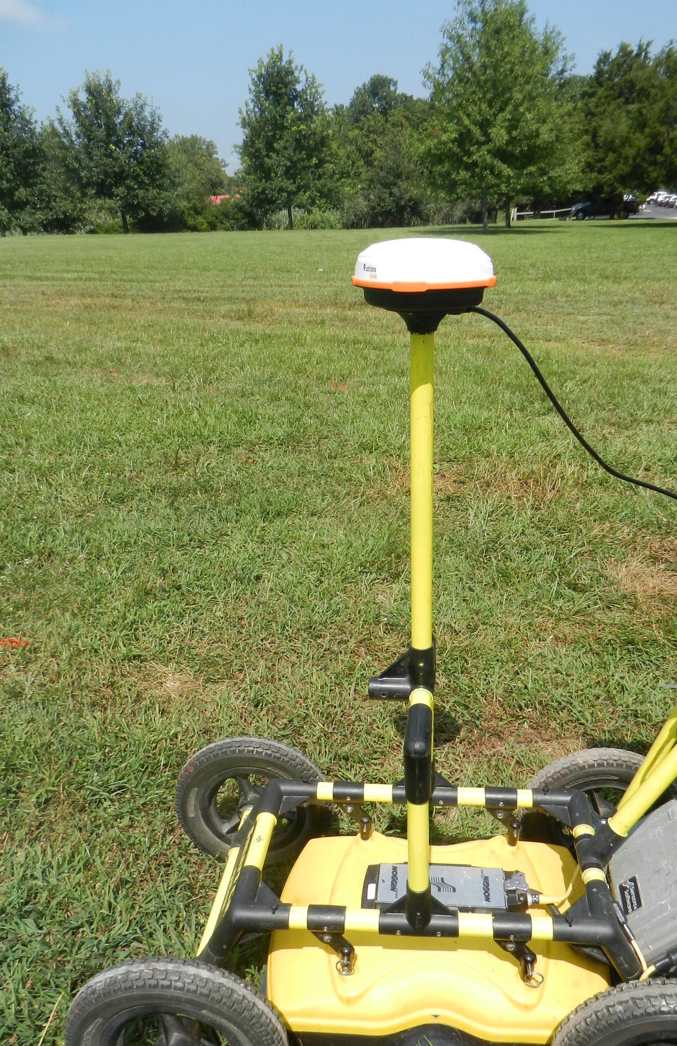
Ground penetrating radar (GPR) is a technology that enables engineers to identify subsurface structures and properties. Different types of GPR equipment are available to suit various applications. All recent systems come with GPS integrated into the council and the ability to add external GPS. Sensors & Softwares pulseEKKO and Noggin systems offer easy-to-use Smartcart packages with antennas ranging from 25 MHz to 1000 MHz. The Noggin system offers antennas operating at 250 MHz, 500 MHz, and 1000 MHz. The pulseEKKO system offers 25 MHz (no Smartcart option), 50 MHz, 200 MHz, and 1000 MHz configurations. Furthermore, their products provide tow handles and tow sleds. Tow handles and sleds are available for projects requiring greater mobility in less favorable conditions. Tow handles and sleds can cover terrain that is often too awkward or difficult for wheeled systems.

Optimized task-specific ground penetrating radar (GPR) systems
are rapidly becoming essential tools for a variety of operations, having a wide range of uses. For concrete scanning, GPR allows workers to create an image of the internal construction of the concrete without any X-ray radiation or other invasive methods. Utility or line locating is benefiting from GPR technology, allowing workers to map potential areas of concern. In icy weather conditions, GPR is being used to map ice thickness – aiding with safety measures and preventing serious accidents. Furthermore, GPR applications can be seen in search and rescue operations to help locate victims more easily than ever before. Finally, multi-frequency and multi-channel techniques are ideal for scanning deep depths and efficiently covering large regions. It’s clear that GPR systems offer a wide range of functions are a key tool for many businesses today.
All systems take full advantage of Sensors & Software’s ekkoProject postprocessing software that is installed on a laptop or PC. Although the software provides numerous options for presenting the results, it has capabilities for repositioning data, advanced data processing capabilities (e.g., filtering, deconvolution, migration, and others,) and options for 3-D presentations. Regardless of the GPR equipment type chosen for a specific project, each provides engineers with reliable data needed to identify subsurface structures unseen by the naked eye.
How does GPR work – theory
Ground penetrating radar (GPR) is a technology that allows engineers to image subsurface materials, including soil and rock.
It works by sending electromagnetic energy pulses into the ground and analyzing their reflections. The apparent conductivity of the material affects how these signals travel, as do its dielectric properties. The frequency of the GPR system is also important. It must be selected depending on what kind of material is being studied, the size of the target, and its depth. GPR images are generated based on reflections caused by different relative permittivities and conductivities of materials, frequency response, and attenuation.
Given the diversity of conductivity among materials like water, air, ice, wood and rock,
it’s clear that the signal strength and speed at which signals propagate through them will vary greatly. For instance, the ideal conditions for GPR scanning are found in cured concrete which is not electrically conductive. This minimizes the absorption of higher-frequency signals, allowing for high-quality imaging during the scan process. In contrast, uncured concrete that is wet and highly conductive will absorb much of the energy from the signal used by GPR scanners. As a result, making uncured concrete an unsuitable environment for scanning.
On the other hand, the signal response can be enhanced by increasing the number of stacks per trace in less than ideal conditions. When layers and targets are difficult to visualize in adverse conditions, increasing the number of “stacks” per trace often enhances image quality. Conventional GPR systems often stack 4 to 64 times per trace, without much difficulty. Unlike all other conventional GPR systems that effectively stack tens of responses, Sensors & Software’s pulseEKKO Ultra GPR system is capable of stacking thousands or tens of thousands of responses to create a single trace. With this enhanced stacking capability the pulseEKKO Ultra GPR system commonly reaches twice the depth of penetration than conventional ground penetrating radar systems. Today, engineers now have access to powerful information about sub-surface materials that were previously not available – aiding in construction projects, archaeology, environmental studies, and more.
Engineering Applications of GPR
GPR is a widely used tool in engineering. Its primary advantage lies in it high resolution and ability to detect targets of various sizes. GPR is a non-destructive testing method used to investigate the ground subsurface. GPR can be used across a variety of mediums, including rock, soil, ice, freshwater, and pavements or structures. Site conditions for GPR will affect the depth of penetration and size of the target that can be achieved.
Civil and Environmental Engineers
Civil engineers use GPR to map potential locations of contaminated soils or locating underground storage tanks. The main advantage of using GPR instead of traditional survey methods is its efficiency. Unlike drilling methods or excavations that rely on trial-and-error. GPR allows engineers to quickly scan large areas without disturbing the environment or creating extra work. Additionally, this technique provides more accurate results spatially. When compared to other methods, GPR excells at its ability to detect incredibly small targets at various depths.
Subsurface Utility Engineering or SUE
Subsurface Utility Engineering (SUE) is a critical aspect of public infrastructure. GPR is an essential tool that SUE professionals use to locate and map buried utility lines, pipes, manhole covers, power cables, gas lines, water mains, sewage systems, and other items that may have been buried or covered up over time.
The accuracy of ground penetrating radar for SUE is critical as it helps minimize costly disruptions or potential hazards from the misplacement of utilities. Additionally, it eliminates the need for trial-and-error approaches to locating underground structures, such as, digging up and searching for manholes or utility access points. It commonly used to locate undocumented abandoned pipes that are no longer in use. All this data can help reduce costs associated with repairs or replacement work. The location of underground services can be determined more easily before any digging begins. Overall, it’s clear that ground penetrating radar plays an important role in Subsurface Utility Engineering. It offers mapping solutions for utilities and underground facilities located beneath the surface and help identify potential problems before they arise.
Mining Engineers
Ground Penetrating Radar (GPR) applications have become increasingly important in the field of mining engineering. This technology utilizes electromagnetic waves to produce images of geological structures and mining resources. GPR is a valuable resource for mining engineers, providing them with an in-depth understanding of their subsurface environment. GPR reveals intricate details about the floors, walls, and ceilings, fault lines, cavities below ground level, and deposits. This information is crucial to have when designing safe tunnels or finding specific materials. GPR has become indispensable in helping miners comprehend the complexities of excavating underground. Systems can also be used to measure the thickness of overburden layers, detect the presence of water or seepage, and accurately map out coal seams or other mineral deposits that may not be visible. By utilizing GPR technology, mining engineers can increase safety and reduce risk when conducting operations in underground environments.
Structural Engineering
GPR (Ground Penetrating Radar) is a highly valuable resource for structural engineers. It allows them to identify and assess potential issues in concrete structures before they become serious problems. GPR can detect cracks, voids, delamination, reinforcing materials, and structural defects that cannot be seen with the naked eye. Additionally, it can be used to map the bedrock beneath roads and pavements, as well as scanning bridges for degradation or damage.
Using GPR for structural engineering applications is an incredibly effective way of detecting problems before they occur. For example, mapping depth to shallow bedrock before designing new road construction; thus, avoiding unnecessary blasting costs. This saves time and money by catching issues early on in the construction process. As such, ground penetrating radar is becoming increasingly popular among structural engineers. In other words, engineers who are looking to ensure their projects are completed safely and efficiently.
Military Applications
Ground penetrating radar is used by the military for various applications. It may be used for detecting underground objects such as unexploded ordnance (UXO), tunnels, and mines. The echnology has been around since the late 1960s and has grown over the years. The military has found several uses for GPR due to its ability to quickly identify unseen objects without having to resort to more laborious methods.

Through GPR, military personnel can survey wide areas. This assists with locating potential hazards before they cause damage or injury, reducing the risk of casualties during military operations. In addition, ground penetrating radar is used by the military to detect tunnels created by enemy combatants. By bouncing signals off underground cavities or openings, these passages can be detected even if they’re inaccessible from above ground routes. This enables troops to identify hostile activity before it’s too late and take effective countermeasures against it.
Find Pages On EngineeringGeophysics.com
Pros and cons of using GPR
Ground Penetrating Radar, is a technology for non-destructive imaging and analysis. Its depth of penetration varies by the subsurface materials, system frequency, and size and depth of the target. While conventional GPR systems are typically able to reach a depth of 25ft in optimal conditions, the pulseEKKO Ultra system from Sensors & Software can generally achieve depths up to twice as deep. While GPR has the potential to scan to a great depth, it can be hindered when scanning in areas with difficult properties such as wet soils or clay. As opposed to ice and solid materials like rock and granite, clay deposits or water can obstruct the unit’s capacity for probing deeper. Additionally, the bandwidths or frequencies employed by the equipment can limit the resolution and depth of penetration. Nonetheless, GPR remains a very useful tool for creating reliable images and measurements of subsurface structures.
Pros of using GPR:
• GPR has the ability to penetrate deeply into materials such as rock, concrete, ice, and air which have low conductivity properties.
• GPR produces vivid two-dimensional cross-sections in color along the profile line. Moreover, it can create plan view presentations of three-dimensional results collected, when collected with a dense grid pattern. This advanced technology offers an image that is far more detailed than those traditionally acquired through other methods.
• Ground Penetrating Radar gives you the capability to explore even the tiniest of targets, including cracks in concrete. Additionally, ground penetrating radar can uncover large objectives such as caves deep within the bedrock. As you explore deeper into the subsurface, remember that your targets must become larger to detect or delineate.
• GPR’s versatility makes it easy to use in many different types of environments.
Cons of using GPR:
• Unfavorable materials can make it difficult for signals to reach their target depth due to a variety of factors. For instance, if the soil is too wet, or has a high clay content with its water absorbency capabilities, then there will be an issue with penetration. Nevertheless, advanced technology, like Sensors & Software pulseEKKO Ultra system, can help ensure that these issues are managed and dealt with properly so that you get great results without compromising on accuracy!
• Metals block signals. This means that buried metal is a hindrance that impedes the passage of transmitted pulses further into the ground.
• GPR is a very successful and precise tool for geophysical engineering. In comparison to electromagnetic conductivity or magnetometer methods, these systems are not practical for continuous mapping of spatially large regions or poor site conditions. For instance, an area that has not been regularly maintained and exceeds many acres may be too taxing on an operator to yield desirable high-resolution results. In such cases, one should consider first utilizing the Geonics EM31 or Geometrics magnetometer to cover large areas; afterward, investigators can focus on specific zones of interest with a site-specific GPR configuration.
Summary
Ground penetrating radar is a type of geophysical survey that uses radar pulses to image the subsurface. GPR is a powerful and highly configurable geophysical tool used by engineers to gain valuable insight into site-specific conditions. This technology has a wide range of potential applications in environmental, engineering, military, and archaeological settings. Ground penetrating radar can detect anomalies in various materials such as soils, rock, concrete, and other low conductivity media through the nondestructive investigation of subsurface properties.
There are several different types of Sensors & Software GPR equipment available on the market
Each suited for specific types of surveys. The principle behind GPR is simple – radars waves are sent into the ground, and when these waves encounter buried features (such as buried metal or utility lines, geologic layers, voids, fractures and faults, and others), they reflect back to the surface where they are recorded by a receiver. By analyzing the data collected, it is possible to generate images of what lies beneath the ground surface. GPR is particularly advantageous in areas where traditional methods may not provide enough detailed information. This makes GPR indispensable in engineering applications. In recent years, ground penetrating radar has become increasingly popular due to its relatively low cost and non-invasive nature. GPR is one of the most common geophysical surveying tools available. Without doubt, GPR has its limits and is subject to certain constraints that must be taken into account before use.